

Site Contractors: Mapping & Volumetrics
Our drone mapping gives site contractors the tools they need to see the whole picture from precise volumes to utility documentation and easy to share visual maps.
What We Provide:
-
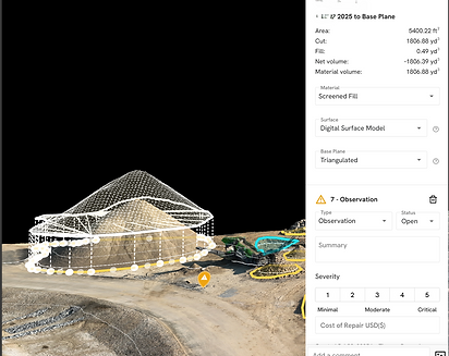
Volumetric calculations of stockpiles
-
Cut & fill analysis for earthworks
-
High resolution 2D maps
-
3D surface models for grading checks
-
Site maps with annotations, measurements, and attached photos/videos
-
Utility documentation and as-built visualization for future reference

Deliverables:
-
Cut/Fill reports
-
Progress maps with annotations
-
Media rich site documentation for crews and management
-
Visuals you can use with data your engineers can leverage

Engineer Integration
-
Share maps, measurements, and site documentation directly with your engineering team
-
Ensure data from drones aligns with their workflows and requirements
-
Optional support to make collaboration easier without adding extra work for you

Marketing Video & Imagery
-
High-quality aerial and ground-based videos tailored for marketing
-
Stunning photos of your site for brochures, websites, or investor materials
-
Highlight milestones, scale, and features of your project
-
Easy to share with stakeholders, clients, or on social media

Why It Matters:
-
Reduce guesswork in earthmoving
-
Document utilities and underground work before cover-up
-
Track progress visually and quantitatively
-
Communicate clearly with engineers and stakeholders when needed
-
Visualize your site with ease and keep crews aligned